- Facebook56
- Threads
- Bluesky
- Total 56
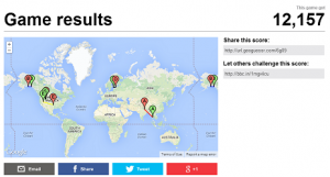
When I need to occupy 10% of my brain and not get distracted by emails, I have recently been playing the BBC’s Geoguessr game. It drops you randomly on a stretch of road that has been photographed by Google Streetview, and you have to guess where you are. Here is my current high score (click through to see if you can beat me).
I started to wonder which roads Google has photographed so far. Certain kinds of scenes kept coming up, whereas vast nations (India, China, Nigeria) are entirely missing. Here is the breakdown based on 100 locations.
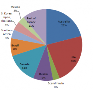
It’s very much an index of road mileage per country in the nations that have been mapped so far, which, in turn, tend to be the wealthier nations of the world. So Australia has roughly 0.3% of the world’s people but 21% of the Google Streetview mileage. (Those “kangaroo crossing” signs are dead giveaways.)
Very common scenes: stretches of two-lane US or Australian highways going through arid open land; long, straight, traffic-less roads through boreal forest; Brazilian highways with lots of trucks and motorcyclists. Almost all the European roads wind through old villages–I’ve never hit a city or a stretch of wilderness in Europe.
Based on this sample, I’d say our world is a beautiful place. If you’re randomly dropped on a stretch of road that has been photographed by Google, at worst, it will be in somewhat bleak wilderness. And best, you will have a stunning view of ancient stone farmhouses, snow-capped peaks, or palm-fringed seashores.
High score = 12,516: http://bbc.in/1s7Cxem
14,733 http://bbc.in/1kjSw82