As described in this slide show, we have been working with college students at Tufts and UMass Boston to build one elaborate “network map” of civil society in the Boston area. The map already has many hundreds of nodes and links; we need to improve the visualization tools so that users can make more sense of the data.
Meanwhile, it has always been our goal to make the map accessible by means of simple applications for Facebook and MySpace. I now feel a little clearer about what those apps. should look like.
On my own Facebook page, I would see a little segment of the Boston-area map with myself at the center and my civic connections around me:
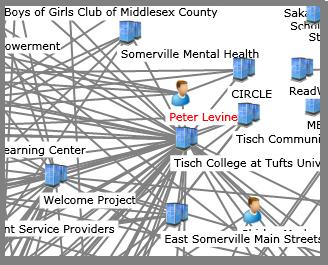
Each of those nodes would be clickable so that anyone on my Facebook page could open them up and see the contact information, mission statements, etc. Moreover, when one clicked on any node, the map would reconfigure to put it in the center, with all its links around it. Thus one could “browse” through Boston’s civil society. One could also search the whole map and put the main search result right in the middle. And one could use the tool to find the shortest path between any two nodes. For instance, if I ever need to talk to the Somerville Mayor’s Office, there’s a path for me via Tisch College and then Tisch College Community Advisers board. This is therefore a tool for community organizing.